Sudden climate change: a warning from 8 millennia ago

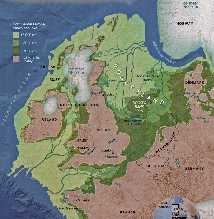
Mesolithic hunter-gatherers in Britain must have had a very hard time around 8.2 thousand years age. The whole area around the North Atlantic experienced sudden climatic cooling of around 3.3°C together with drought that lasted about 70 years. To make things worse shortly afterwards, coasts around the North were devastated by a tsunami generated by a submarine landslide off western Norway. That event exceeded the maximum coast ‘run up’ of both the 26 December 2004 Indian Ocean tsunami and that in NW Japan on 11 March 2011. Doggerland, then in the central North Sea was devastated by a catastrophic event of a few days duration. It littered the seabed with the bones of its megafauna and even Mesolithic tools recovered by trawlers from its surviving relic the shallow Dogger Bank. It seems the tsunami arrived just as climate was warming back to ‘normal’ Holocene conditions: for many foragers, surely, a last straw.

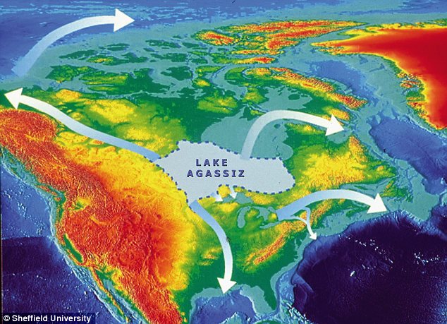
The cooling episode has been attributed to perturbation of the Atlantic Meridional Overturning Circulation (AMOC) as a result of meltwater discharge during the deglaciation of the Laurentide Ice Sheet (see: Just when you think it’s going to turn out alright… November 2009).The event may have unfolded in a similar fashion to the trigger for the Younger Dryas and the succession of warming-cooling episodes known as Dansgaard-Oeschger events that interrupted the otherwise relentless global cooling towards the last glacial maximum (see: Review of thermohaline circulation; February 2002). The physics that set off such climatic ‘hiccups’ is that freshening of surface seawater reduces its density, so that it cannot sink to be replaced by denser saline water ‘dragged’ northwards from warmer latitudes. That currently takes the form of the Gulf Stream with its warming influence, particularly in the eastern North Atlantic and even beyond Norway’s North Cape, responsible for much warmer winters than at similar latitudes on the western side. The culprit  had long been suggested to be the drainage of a huge lake dammed by the ice sheet that covered most of eastern Canada during late stages of deglaciation. Seemingly the best candidate was Lake Agassiz trapped by the early Holocene ice front in Manitoba – the largest proglacial lake known anywhere.

Colour coded topographic elevation of North America showing the maximum extent of Lake Agassiz and four possible routes for its drainage: north-west to the Arctic Ocean via the Mackenzie River; south to the Gulf of Mexico via the Mississippi valley; east to the North Atlantic via the Great Lakes and St Laurence River; north to the North Atlantic via Hudson Bay. (Credit: ©Sheffield University)

The present landforms of central Canada show evidence for several outflow directions at different times, Including to the northwest to reach the Arctic Ocean at the onset of the Younger Dryas. Until recently there was little detailed evidence for the flow volume and timing of its drainage around 8 to 9 ka. Providing the details in the context of the short-lived event around 8.2 ka requires accurate data over a mere 200 years able to reveal a change in sea level to a precision of better than a few tens of centimetre. Any site on the shores of the North Atlantic would do, provided it satisfies these criteria. Geographers from universities in York, Leeds, Sheffield and Oxford, UK selected the small estuary of the River Ythan in NE Scotland. There, a continuous sand unit just above fine-grained intertidal tidal muds marks the knife-sharp time datum of the Storegga tsunami (Rush, G. et al. 2023. The magnitude and source of meltwater forcing of the 8.2 ka climate event constrained by relative sea-level data from eastern Scotland. Quaternary Science Advances, v. 12, article 100119; DOI: 10.1016/j.qsa.2023.100119).

Cores of the intertidal sediments from beneath the present Ythan salt marsh contain plant remains that yielded precise radiocarbon dates at several stratigraphic levels from which to derive an age-depth model for the age range of interest. The buried sediments are also rich in marine microfossils (foraminifera and diatoms) that thrive in estuaries at a variety of depths.  These enabled fluctuations in relative sea level during the build-up of the intertidal sediments to be constrained at unprecedented resolution and precision for a three thousand year period from 9.5 to 6.5 ka. The authors show that there were two episodes of rapid sea-level rise over that time: between 8.53 and 8.37 ka (~2.4 m at 13 mm yr-1) and 8.37 to 8.24 ka (~ 0.6 m at 4 mm yr-1) – these would have been global increases in sea level.

Despite its vast size, it turns out that Lake Agassiz would have been unable to result in sea-level rises of that magnitude so quickly merely through outflow. Rush et al. suggest that the huge  and rapid addition of fresh water to the North Atlantic involved flow of lake water towards Hudson Bay, beneath the ice sheet, causing it to collapse and melt, followed by completion of Lake Agassiz’s emptying in the second stage. It took a long drawn-out ‘freshening’ of the North Atlantic surface water ultimately to shut down the Atlantic Meridional Overturning Circulation, thereby depriving high latitudes of its east-side warming effect by the Gulf Stream.

Sea level has been rising since the early 20th century mainly through the melting of Greenland’s ice cap together with a substantial amount of thermal expansion while global climate has been warming. Between 1901 and 2018 the rise has amounted to 15 to 25 cm at a rate of 1 to 2 mm yr-1. The AMOC is possibly weaker now than at any time during the last millennium (Zhu, C. et al. 2023. Likely accelerated weakening of Atlantic overturning circulation emerges in optimal salinity fingerprint. Nature Communications, v. 14, article 1245; DOI: 10.1038/s41467-023-36288-4). Yet increases in freshening of the northernmost parts of the North Atlantic are now being added to by annual increases in the melting of polar sea ice, which is salt-free. The AMOC may be approaching a tipping point, because warming is accelerating over Greenland at around 1.5°C each year: faster than most of the rest of the world. In 2021 it rained for the first time ever recorded at the ice cap’s summit (3.2 km above sea level). A ‘perturbation’ of the AMOC would add chaos to the dominantly linear view of global warming taken by climatologists. That could launch frigidity and drought at mid northern latitudes as it did eight millennia ago: the opposite of what is currently feared.

See also: Unlocking Ancient Climate Secrets – Melting Ice Likely Triggered Climate Change Over 8,000 Years Ago. Scitechdaily 16 September 2023.

Doggerland and the Storegga tsunami

Britain is only an island when sea level stands high; i.e. during interglacial conditions. Since the last ice age global sea level have risen by about 130 m as the great northern ice sheets slowly melted. That Britain could oscillate between being part of Europe and a large archipelago as a result of major climatic cycles dates back only to between 450 and 240 ka ago. Previously it was a permanent part of what is now Europe, as befits its geological identity, joined to it by a low ridge buttressed by Chalk across the Dover Strait/Pas de Calais. All that remains of that are the white cliffs on either side. The drainage of what became the Thames, Seine and Rhine passed to the Atlantic in a much larger rive system that flowed down the axis of the Channel. Each time an ice age ended the ridge acted as a dam for glacial meltwater to form a large lake in what is now the southern North Sea. While continuous glaciers across the northern North Sea persisted the lake remained, but erosion during interglacials steadily wore down the ridge. About 450 ka ago it was low enough for this pro-glacial lake to spill across it in a catastrophic flood that began the separation. Several repeats occurred until the ridge was finally breached (See: When Britain first left Europe; September 2007). Yet sufficient remained that the link reappeared when sea level fell. What remains at present is a system of shallows and sandbanks, the largest of which is the Dogger Bank roughly halfway between Newcastle and Denmark. Consequently the swamps and river systems that immediately followed the last ice age have become known collectively as Doggerland.

The shrinkage of Doggerland since 16,000 BCE (Credit: Europe’s Lost Frontiers Project, University of Bradford)

Dredging of the southern North Sea for sand and gravel frequently brings both the bones of land mammals and the tools of Stone Age hunters to light – one fossil was a skull fragment of a Neanderthal. At the end of the Younger Dryas (~11.7 ka) Doggerland was populated and became a route for Mesolithic hunter-gatherers to cross from Europe to Britain and become transient and then permanent inhabitants. Melting of the northern ice sheets was slow and so was the pace of sea-level rise. A continuous passage across Dogger Land  remained even as it shrank. Only when the sea surface reached about 20 m below its current level was the land corridor breached bay what is now the Dover Strait, although low islands, including the Dogger Bank, littered the growing seaway. A new study examines the fate of Doggerland and its people during its final stage (Walker, J. et al. 2020. A great wave: the Storegga tsunami and the end of Doggerland? Antiquity, v. 94, p. 1409-1425; DOI: 10.15184/aqy.2020.49).

James Walker and colleagues at the University of Bradford, UK, and co-workers from the universities of Tartu, Estonia, Wales Trinity Saint David and St Andrews, UK, focus on one devastating event during Doggerland’s slow shrinkage and inundation. This took place around 8.2 ka ago, during the collapse of a section of the Norwegian continental edge. Known as the Storegga Slides (storegga means great edge in Norse), three submarine debris flows shifted 3500 km3 of sediment to blanket 80 thousand km2 of the Norwegian Sea floor, reaching more than half way to Iceland.  Tsunami deposits related to these events occur along the coast western Norway, on the Shetlands and the shoreline of eastern Scotland. They lie between 3 and 20 m above modern sea level, but allowing for the lower sea level at the time the ‘run-up’ probably reached as high as 35 m: more than the maximum of both the 26 December 2004 Indian Ocean tsunami and that in NW Japan on 11 March 2011. Two Mesolithic archaeological sites definitely lie beneath the tsunami deposit, one close to the source of the slid, another near Inverness, Scotland. At the time part of the Dogger Bank still lay above the sea, as did a wide coastal plain and offshore islands along England’s east coast. This catastrophic event was a little later than a sudden cooling event in the Northern Hemisphere. Any Mesolithic people living on what was left of Doggerland would not have survived. But quite possibly they may already have left as the climate cooled substantially

A seabed drilling programme financed by the EU targeted what lies beneath more recent sediments on the Dogger Bank and off the embayment known as The Wash of Eastern England. Some of the cores contain tsunamis deposits, one having been analysed in detail in a separate paper (Gaffney, V. and 24 others 2020. Multi-Proxy Characterisation of the Storegga Tsunami and Its Impact on the Early Holocene Landscapes of the Southern North Sea. Geosciences, v. 10, online; DOI: 10.3390/geosciences10070270). The tsunami washed across an estuarine mudflat into an area of meadowland with oak and hazel woodland, which may have absorbed much of its energy. Environmental DNA analysis suggests that this relic of Doggerland was roamed by bear, wild boar and ruminants. The authors also found evidence that the tsunamis had been guided by pre-existing topography, such as the river channel of what is now the River Great Ouse. Yet they found no evidence of human occupation. Together with other researchers, the University of Bradford’s Lost Frontiers Project have produced sufficient detail about Doggerland to contemplate looking for Mesolithic sites in the excavations for offshore wind farms.

See also: Addley, E. 2020.  Study finds indications of life on Doggerland after devastating tsunamis. (The Guardian, 1 December 2020); Europe’s Lost Frontiers website

A tsunami and NW European Mesolithic settlements

About 8.2 ka ago sediments on the steep continental edge of the North and Norwegian Seas slid onto the abyssal plain of the North Atlantic. This huge mass displacement triggered a tsunami whose effects manifest themselves in sand inundations at the heads of inlets and fjords along the Norwegian and eastern Scottish coasts that reach up to 10 m above current sea level. At that time actual sea level was probably 10 m lower than at present as active melting of the last glacial ice sheets was still underway: the waves may have reached 20-30 m above the 8.2 ka sea level. So powerful were the tsunami waves in the constricted North Sea that they may have separated the British Isles from the European mainland by inundating Doggerland, the low-lying riverine plain that joined them before global sea level rose above their elevation at around the same time. Fishing vessels plying the sandbanks of the southern North Sea often trawl-up well preserved remains of land mammals and even human tools: almost certainly Doggerland was prime hunting territory during the Mesolithic, as well as an easily traversed link to the then British Peninsula. Mesolithic settlements close by tsunami deposits are known from Inverness in Scotland and Dysvikja north of Bergen in Norway and individual Mesolithic dwellings occur on the Northumberland coast. The tsunami must have had some effect on Mesolithic hunter gatherers who had migrated into a game-rich habitat. The question is: How devastating was it.

English: Maelmin - reconstruction of Mesolithi...
Reconstruction of Mesolithic hut based on evidence from two archaeological sites in Northumberland, UK. (credit: Lisa Jarvis; see http://www.maelmin.org.uk/index.html )

Hunter gatherers move seasonally with favoured game species, often returning to semi-permanent settlements for the least fruitful late-autumn to early spring season. The dominant prey animals, red deer and reindeer also tend to migrate to the hills in summer, partly to escape blood-feeding insects, returning to warmer, lower elevations for the winter. If that movement pattern dominated Mesolithic populations then the effects of the tsunami would have been most destructive in late-autumn to early spring. During warmer seasons, people may not even have noticed its effects although coastal habitations and boats may have been destroyed.

Splendid Feather Moss, Step Moss, Stair Step Moss
Stair-step moss (credit: Wikipedia)

Norwegian scientists Knut Rydgren and Stein Bondevik from Sogn og Fjordane University College, Sognda devised a clever means of working out the tsunami’s timing from mosses preserved in the sand inundations that added to near-shore marine sediments. (Rydgren, K. & Bondevik, S. 2015. Most growth patterns and timing of human exposure to a Mesolithic tsunami in the North Atlantic. Geology, v. 43, p. 111-114). Well-preserved stems of stair-step moss Hylocomium splendens still containing green chlorophyll occur, along with ripped up fragments of peat and soil, near the top of the tsunami deposit which has been uplifted by post-glacial isostatic uplift to form a bog. This moss grows shoots annually, the main growth spurt being at the end of the summer-early autumn growing season. Nineteen preserved samples preserved such new shoots that were as long as or longer than the preceding year’s shoots. This suggests that they were torn up by the tsunami while still alive towards the end of the growing season, around late-October. All around the North Sea Mesolithic people could have been returning from warm season hunting trips to sea-shore winter camps, only to have their dwellings, boats and food stores devastated, if indeed they survived such a terrifying event.