How India accelerated towards Eurasia at the end of the Cretaceous

About 70 Ma ago the magnetic striping of the Indian Ocean floor suggests that the Indian subcontinent was then moving towards the huge, almost stationary Eurasian continent at about 8 cm per year. Over the next 5 Ma this convergence rate underwent a tectonically startling acceleration to reach 18 cm yr-1 by around the time of the Cretaceous-Palaeogene boundary (65 Ma): more than doubling the approach rate. Thereafter it slowed, eventually to a few centimetres per year once collision and building of the Himalayan mountain belt were more or less complete about 30 Ma ago. This cannot easily be explained by a speeding up of the sea-floor spreading rate at an Indian Ocean ridge to the south, 18 cm yr-1 being as fast as tectonic forces can manage at present. At that time ocean floor to the north of India was being subducted beneath Eurasia, and basaltic volcanism was flooding what is now the Deccan Plateau on western India. A couple of suggestions have been made: two northward subduction zones may have developed or the mantle plume feeding the Deccan flood basalts may have driven the tectonic acceleration. A third possibility is that the subduction was somehow lubricated. That approach has recently been considered by geoscientists from China and Singapore  (Zhou, H. et al. 2024. India–Eurasia convergence speed-up by passive-margin sediment subduction. Nature, v. 635, p. 114-120; DOI: 10.1038/s41586-024-08069-6).

Hao Zhou and colleagues studied the isotopic and trace-element geochemistry of volcanic and plutonic igneous complexes to the north of the Himalaya. They were emplaced in arc environments in three stages: from 98 to 89; 65 to 60; and 57 to 50 Ma. In this tectonic setting fluids rise from the subducted slab to induce the mantle part of the overriding lithosphere to partially melt. That yields magmas which penetrate the crust above. The first and last magmatic events produced similar isotopic and trace-element ‘signatures’, which suggest fluids rose from subducted ocean lithosphere.  But those in the latest Cretaceous to earliest Palaeocene are markedly different. Instead of showing signs of their magmas being entirely mantle derived like the earlier and later groups, the 65 to 60 Ma rocks exhibit clear evidence of partial melting having incorporated materials that had originated in older continental crust. The authors suggest that this crustal contamination stemmed from sediments that had been deposited at the northern margin of the Indian subcontinent during the Mesozoic. These sediments had formed by weathering of the ancient rocks that underpin India, transport of the debris by rivers and deposition on the seafloor as water-saturated sands, silts and clays. Once those sediments were subducted beneath what is now Tibet they would yield fluids with a geochemical ‘fingerprint’ inherited from old continental crust. Moreover, far more fluids than subducted oceanic crust could ever release would rise into the overriding lithosphere than.

The fluids rising from a subducted wedge of sediments may have reduced friction between the overriding Eurasian lithosphere and the subducted slab derived from the Indian tectonic plate. That scenario would not only have lubricated subduction, but allowed compressive forces in the overriding lithosphere to relax. Both would have allowed convergence of the two plates to move significantly faster as the sediments were progressively consumed. Once completed, convergence would have slowed without such ‘lubrication’.Earlier continent-continent collision zones, such as those that united Pangaea and older supercontinents may well have involved such tectonic surges. And the same kind of process may eventually speed up the reassembly of the latest distribution of continents.

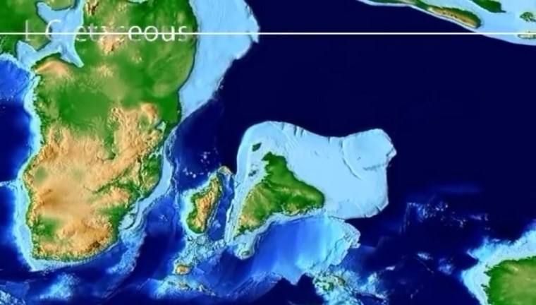
Watch an animation of the India-Eurasia convergence (just over 3 minutes long)compiled by Christopher Scotese of Northwestern University in Evanston, Illinois, USA, which is a component of his Paleomap Project. It starts by following India from its current position to its origin in the break-up of Gondwanaland ~100 Ma ago. The last half reverses the motions to show India’s slow collision with Eurasia.

Subduction and continental collision in the Himalaya

The Indian subcontinent after it separated from Madagascar in the Late Cretaceous to move northwards to its destined collision with Eurasia and the formation of the Himalaya. (Credit: Frame from an animation ©Christopher Scotese)

During the Early Cretaceous (~140 Ma ago) India, Madagascar, Antarctica and Australia parted company with Africa after 400 Ma of unity as components of the Gondwana supercontinent. By 120 Ma Antarctica and Australia split from India and Madagascar, and the Indian Ocean began to form. India moved northwards , leaving Madagascar in its wake after about 70 Ma ago. By 50 Ma the subcontinent began to collide with Eurasia, its northward motion driving before it crustal materials that eventually formed the Himalaya. This highly complex process is wonderfully documented in an animation made in 2015 by Christopher Scotese, Emeritus Professor in the Department of Earth and Environmental Sciences, Northwestern University, USA. At the start of its journey India moved northwards at a slow rate of about 5 cm per year. After 80 Ma it speeded up dramatically to 15 cm per year, about twice as fast as any modern continental drift and a pace that lasted for over 30 Ma until collision began. How could that, in a geological sense, sudden and sustained acceleration have been induced? It would have required a change in the slab-pull force that is the primary driver of plate tectonics, suggesting an increase in the amount of subduction in the Tethys Ocean that formerly lay between India and Eurasia, probably at two, now hidden destructive plate margins.

A group of geoscientists from Canada, the US and Pakistan has documented that collision in terms of the record of metamorphism experienced beneath the Himalaya as slab after slab of once near-surface rocks were driven beneath the rising orogen (Soret, M. et al. 2021. How Himalayan collision stems from subduction. Geology, v. 49, p. 894-898; DOI: 10.1130/G48803.1). The Western Himalaya has trapped a deformed and tilted magmatic rock sequence of an island arc – the Kohistan Arc – between  the Eurasian plate and a zone of crustal thickening and shortening that was thrust southward over the ancient metamorphic basement of India itself. That crust was mantled by a variety of younger sediments deposited on the Tethyan continental shelf of the northern Indian plate which became involved in the process of crustal thickening. The Kohistan Arc probably formed above one of the destructive margins that consumed the oceanic lithosphere of the now vanished Tethys Ocean. Two distinct types of rock make up the slabs stacked-up by thrusting.

The uppermost, which also forms the highest part of the Western Himalaya in the form of Nanga Parbat (at 8,126 metres the world’s ninth highest mountain) comprises rocks thought to represent Tethyan oceanic lithosphere subducted perhaps at the second destructive margin. Their mineral assemblages, especially those of eclogites, indicate that they have been metamorphosed under pressures corresponding to depths of up to 100 km, but at low temperatures along a geothermal gradient of about 7°C km-1, i.e. in a low heat-flow environment. These ultra-high pressure (UHP) metamorphic rocks formed at the start of the India-Eurasia collision. The sequence of sedimentary slabs now overridden by the UHP slab were metamorphosed at around the same time, but under very different conditions. Their burial reached only about 35 km – the normal thickness of the continental crust – and a temperature of about 600°C on a 30°C km-1 geothermal gradient. Detailed mineralogy of the UHP slab reveals that as it was driven over the metasediments it evolved to the same geothermal conditions.

Matthew Soret and his colleagues explain how this marked metamorphic duality may have arisen in rocks that are now part of the same huge thrust complex. Their results are consistent with slicing together of oceanic lithosphere in a subduction zone to form a tectonic wedge of UHP mineral assemblages at the same time as continental shelf sediments were metamorphosed under more normal geothermal conditions. This was happening just as India came into contact with Eurasia. When crustal thickening began in earnest through the inter-slicing of the two assemblages, pressure on the UHP rocks fell rapidly as a result of their being thrust over the dominantly metasedimentary shelf sequence. It also moved into a zone of normal heat flow, first heating up equally quickly and then following a path of decreasing pressure and temperature as erosion pared away the newly thickened crust. Both assemblages now became part of the same metamorphic regime. In this way a subduction system evolved to become incorporated in an orogenic zone as two continents collided; a complex process that finds parallels in other orogens such as the Alps.

Indian groundwater shortage threatens food production

Farmers in India have been engaged in mass protests since September 2020. Their anger is directed at a series of laws introduced by the central government of Narendra Modi’s  Bharatiya Janata Party (BJP) that change farmers’ terms of trade. Agriculture in India also faces a future of reduced availability of groundwater on which farmers have become increasingly dependent, especially in the vast alluvial plains of the Ganges river system. The twin satellites of the Gravity Recovery  and Climate Experiment (GRACE), which chart changes in mass beneath the Earth’s surface, detected a major change in gravity over 3 million km2 of India’s largest area of agriculture in the northwestern Gangetic plains (Rodell, M. et al. 2009. Satellite-based estimates of groundwater depletion in India. Nature, v. 460, p.999-1002; DOI: 10.1038/nature08238). The data suggested a loss between 2002 and 2008 of around 109 cubic kilometres of water from the aquifers that support regional irrigation and the livelihoods of about 114 million people (see NASA summary). The loss of water and decline in well-water levels have continued since then.

Colour-coded GRACE data  from 2002 to 2008 showing the estimated drawdown in water levels in wells in NW India and NE Pakistan during this period. Green to dark-red colours indicate from 0 to 12 metres of decline (credit: Trent Schindler and Matt Rodell, NASA)

A recent comprehensive survey (Jain, M. and 8 others 2021. Groundwater depletion will reduce cropping intensity in India. Science Advances, v. 9, article eabd2849; DOI: 10.1126/sciadv.abd2849) uses satellite image and census data to document the actual changes in winter crops (those most dependent on irrigation) over the period 2001 to 2012. It roughly measures the realities of the unsustainable extraction of groundwater indicated by GRACE from 2002 to 2008. The study projects an average reduction of 20% in winter cropping across the whole of India, with some of the worst-hit areas being likely to experience a 68% loss. The dominant supplies of irrigation water are from countless tube wells and systems of canals supplied by dams or rivers. India has witnessed impressive gains in food production in the last half century, thanks to rapid and continuing growth in the number of tube wells driven by individual farmers. The livelihoods of about 600 million people depend on agriculture. There is no prospect of substituting either form of irrigation to maintain current levels of production. If increased canal supply was used to replace well water and reduce groundwater depletion, cropping intensity would still decline, albeit at about half the projected rate; however, that doesn’t take into account unpredictable droughts in surface water accumulation and movement.

Faced with this situation, it is hardly surprising that farmers fear for their families future and react massively to state intervention in their marketing and crop storage strategies.

For a wider context to the Indian agricultural crisis see also: The ecological roots of India’s farming crisis (Deutche Welle, 1 February, 2021)