Bone tools widened hominins foraging options 1.5 Ma ago

Hominins have been making and using stone tools since at least 3.4 Ma, as shown by cut marks on bones and stone artefacts themselves. I use the sack term ‘hominin’ because the likely makers and users of the oldest tools are either australopithecines or paranthropoids, there being no fossils designates to the genus Homo of late-Pliocene age. So it might seem  un-newsworthy to report that the oldest tools deliberately made from bone are now known to occur in 1.5 Ma old sediments from the famous sedimentary sequence at Olduvai Gorge in Tanzania (de la Torre, I and 8 others2025. Systematic bone tool production at 1.5 million years ago. Nature, v. 639; DOI: 10.1038/s41586-025-08652-5). To be clear, there is abundant evidence that hominins had used bones, especially sturdy long bones, for digging perhaps, much earlier in hominin history. Again, paranthropoids have been implicated in their use. The bones found at Olduvai actually show signs of manufacture into useful objects prior to their use: they show clear signs of knapping to produce points and blades. The bones are among the sturdiest known from the Pleistocene, being from elephants and hippos. Before de la Torre and colleagues found what is essentially a bone-tool factory, it was thought that systematic use of bones in such a sophisticated manner only arose between 400 to 250 ka ago among early Homo in Europe. Sadly, fossils of whoever made the tools were not found at the site. Once again, paranthropoids as well as early Homo  are known to have cohabited the area at that time.

‘Front, back and side’ views of a 1.5 Ma old tool made from an elephant humerus – its upper foreleg. The scale bar represents 5 cm. (Credit: de la Torre et al.; Fig 3a)

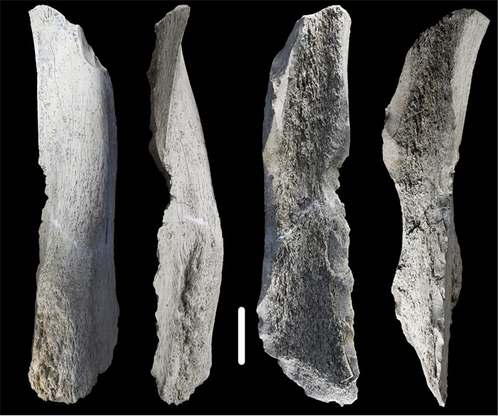
Bifacial Acheulean stone artefacts first appear in the rock record about 300 ka before these bone tools were made. So one idea that the authors put forward is that the same kind of stone knapping technique was transferred to the more abundant massive bones of the East African Pleistocene megafauna (in the absence or rarity of suitable blocks of stone?). But it remains unclear whether or not such tools were simply selected from very large bones smashed to get at their nutritious marrow. The first possibility implies a cultural shift, whereas the latter points simply to expedience. The authors are at pains to point out that the curious million-year gap in the record of bone tools may be ascribed either to the disappearance of bone technology or simply to archaeologists who worked elsewhere having not regarding bone fragments as the products of skills. That applies equally to earlier times, when bones were indeed used, though with not so much in the way of a ‘mental template’. As de la Torre et al. conclude ‘Future research needs to investigate whether similar bone tools were already produced in earlier times, persisted during the Acheulean and eventually evolved into Middle Pleistocene bone bifaces similar in shape, size and technology to their stone counterparts’.

Tsunami risk in East Africa

The 26 December 2004 Indian Ocean tsunami was one of the deadliest natural disasters since the start of the 20th century, with an estimated death toll of around 230 thousand. Millions more were deeply traumatised, bereft of homes and possessions, rendered short of food and clean water, and threatened by disease. Together with that launched onto the seaboard of eastern Japan by the Sendai earthquake of 11 March 2011, it has spurred research into detecting the signs of older tsunamis left in coastal sedimentary deposits (see for instance: Doggerland and the Storegga tsunami, December 2020). In normally quiet coastal areas these tsunamites commonly take the form of sand sheets interbedded with terrestrial sediments, such as peaty soils. On shores fully exposed to the ocean the evidence may take the form of jumbles of large boulders that could not have been moved by even the worst storm waves.

Sand sheets attributed to a succession of tsunamis, interbedded with peaty soils deposited in a swamp on Phra Thong Island, Thailand. Note that a sand sheet deposited by the 2004 Indian Ocean tsunami is directly beneath the current swamp surface (Credit: US Geological Survey)

Most of the deaths and damage wrought by the 2004 tsunami were along coasts bordering the Bay of Bengal in Indonesia, Thailand, Myanmar, India and Sri Lanka, and the Nicobar Islands. Tsunami waves were recorded on the coastlines of Somalia, Kenya and Tanzania, but had far lower amplitudes and energy so that fatalities – several hundred – were restricted to coastal Somalia. East Africa was protected to a large extent by the Indian subcontinent taking much of the wave energy released by the magnitude 9.1 to 9.3 earthquake (the third largest recorded) beneath Aceh at the northernmost tip of the Indonesian island of Sumatra. Yet the subduction zone that failed there extends far to the southeast along the Sunda Arc. Earthquakes further along that active island arc might potentially expose parts of East Africa to far higher wave energy, because of less protection by intervening land masses.

This possibility, together with the lack of any estimate of tsunami risk for East Africa, drew a multinational team of geoscientists to the estuary of the Pangani River  in Tanzania (Maselli, V. and 12 others 2020. A 1000-yr-old tsunami in the Indian Ocean points to greater risk for East Africa. Geology, v. 48, p. 808-813; DOI: 10.1130/G47257.1). Archaeologists had previously examined excavations for fish farming ponds and discovered the relics of an ancient coastal village. Digging further pits revealed a tell-tale sheet of sand in a sequence of alluvial sediments and peaty silts and fine sands derived from mangrove swamps. The peats contained archaeological remains – sherds of pottery and even beads. The tsunamite sand sheet occurs within the mangrove facies. It contains pebbles of bedrock that also litter the open shoreline of this part of Tanzania. There are also fossils; mainly a mix of marine molluscs and foraminifera with terrestrial rodents fish, birds and amphibians. But throughout the sheet, scattered at random, are human skeletons and disarticulated bones of male and female adults, and children. Many have broken limb bones, but show no signs of blunt-force trauma or disease pathology. Moreover, there is no sign of ritual burial or weaponry; the corpses had not resulted from massacre or epidemic. The most likely conclusion is that they are victims of an earlier Indian Ocean tsunami. Radiocarbon dating shows that it occurred at some time between the 11th and 13th centuries CE. This tallies with evidence from Thailand, Sumatra, the Andaman and Maldive Islands, India and Sri Lanka for a major tsunami in 950 CE.

Computer modelling of tsunami propagation reveals that the Pangani River lies on a stretch of the Tanzanian coast that is likely to have been sheltered from most Indian Ocean tsunamis by Madagascar and the shallows around the Seychelles Archipelago. Seismic events on the Sunda Arc or the lesser, Makran subduction zone of eastern Iran may not have been capable of generating sufficient energy to raise tsunami waves at the latitudes of the Tanzanian coast much higher than those witnessed there in 2004, unless their arrival coincided with high tide – damage was prevented in 2004 because of low tide levels. However, the topography of the Pangani estuary may well amplify water level by constricting a surge. Such a mechanism can account for variations of destruction during the 2011 Tohoku-Sendai tsunami in NE Japan.

If coastal Tanzania is at high risk of tsunamis, that can only be confirmed by deeper excavation into coastal sediments to check for multiple sand sheets that characterise areas closer to the Sunda Arc. So far, that in the Pangani estuary is the only one recorded in East Africa