
By using artificially generated microwaves to illuminate the Earth’s surface it is possible to create images. The technology and the theory behind this radar imaging are formidable. After about 30 years of development using aircraft-mounted transmission and reception antennas, the first high resolution images from space were produced in the late 1970s. Successive experiments improved and expanded the techniques, and for the last decade radar surveillance has been routine from a number of orbiting platforms. Radar has two advantages over optical remote sensing: being an active system it can be done equally effectively day or night; it also penetrates cloud cover, which is almost completely transparent to microwaves with wavelengths between a centimetre and a metre. The images are very different from those produced by visible or infrared radiation, the energy returns from the surface being controlled by topography and the roughness of the surface. One of many complicating factors is that images can only be produced by oblique illumination. That, together with deployment of widely separated transmission and reception antennas, opens up the possibility of extracting very-high precision (millimetre) measurements of topographic elevation.
In 1992 radar data from two overpasses of the European ERS-1 satellite over California were processed to capture interference due to changes in the ground elevation during the time between the two orbits: the first interferometric radar or InSAR. It revealed the regional ground motions that resulted from the magnitude 7.3 Landers earthquake at 4:57 am local time on June 28, 1992. For the last decade InSAR has become a routine tool to monitor globally both lateral and vertical ground movements, whether rapid, as in earthquakes, or slow in the case of continental plate motions, subsidence or the inflation of volcanoes prior to eruptions. Juliet Biggs and Tim Wright, respectively of the Universities of Bristol and Leeds, UK, have summarised InSAR’s potential (Biggs, J. & Wright, T.J. 2020. How satellite InSAR has grown from opportunistic science to routine monitoring over the last decade. Nature Communications, v. 11, p. 1-4; DOI: 10.1038/s41467-020-17587-6).
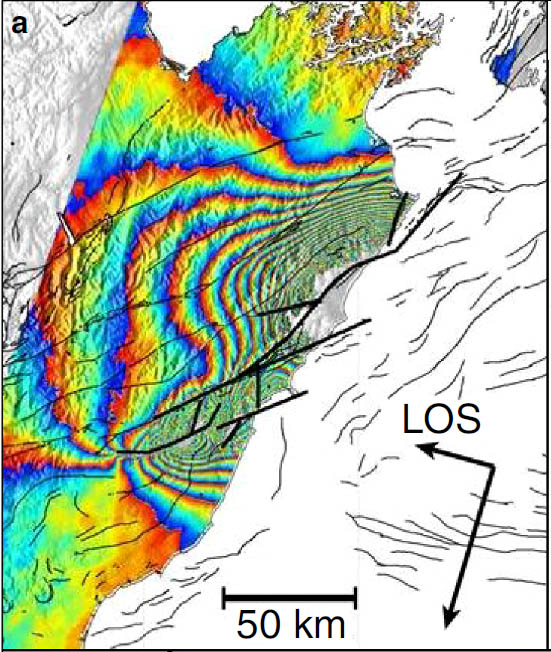
Since the ERS-1 satellite discovered the ground motions associated with the Landers earthquake, InSAR has covered more than 130 large seismic events. Although the data post-dated the damage, they have demonstrated the particular mechanics of each earthquake, allowing theoretical models to be tested and refined. In the image above it is clear that the motions were not associated with a single fault in New Zealand: the Kaikoura earthquake involved a whole network of them, at least at the surface. Probably, displacement jumped from one to another; a complexity that must be taken into account for future events on such notorious fault systems as those in densely populated parts of California and Turkey.
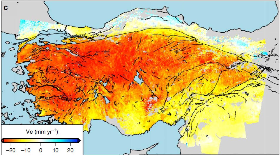
Since its inception, GPS has proved capable of monitoring tectonic motions over a number of years, but only for widely spaced, individual ground instruments. Using InSAR alongside years’ worth of GPS measurements helps to extend detected motions to much finer resolution, as the image above shows for Asiatic Turkey. An important parameter needed for prediction of earthquakes is the way in which crustal strain builds up in regions with dangerously active fault systems.
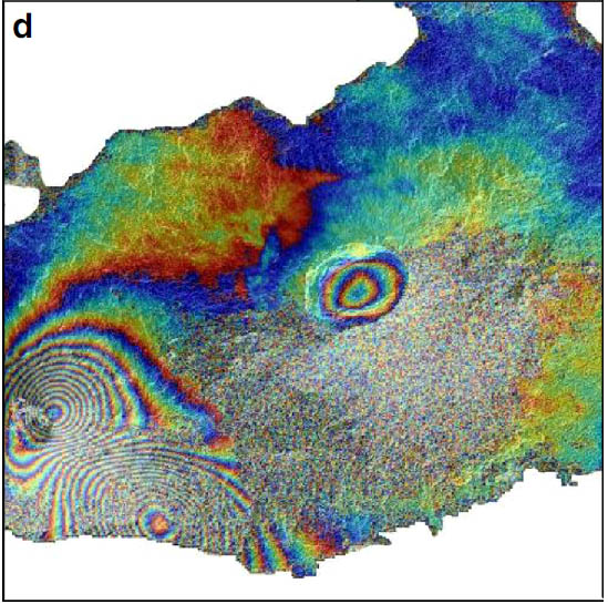
Volcanism obviously involves the movement of large masses of magma beneath the surface before eruptions. GPS and micro-gravity measurements show that charging of a magma chamber causes volcanoes to inflate so InSAR provides a welcome means of detecting the associated uplift, even if it only a few centimetres, as show by the example above from the Galapagos Islands. A volcano’s flanks may bulge, which could presage a lateral eruption or a pyroclastic flow such as that at Mount St Helens in 1980. Truly vast eruptions are associated with calderas whose ring faults may cause collapse in advance.
The presence of cavities beneath the surface, formed by natural solution of limestones, deliberately as in extraction of brines from salt deposits or after subsurface mining, present subsidence hazards. There have been several series of alarming TV programmes about sinkhole formation that demonstrate sudden collapse. Yet every case will have been preceded by years of gradual sagging. InSAR allows risky areas to be identified well in advance of major problems. Indeed estate agents (realtors) as well as planners, civil engineers and insurers form a ready market for such survey.

