

East Africa is traversed from the Afar Depression in the north to Malawi in southern Africa by several great depressions bounded by active normal fault systems: grabens in the old terminology. They are regions of active crustal extension and thinning decorated by chains of active volcanoes. The last 50 years has witnessed more than 3400 major earthquakes (magnitude 4 to 7); unsurprising for the Earth’s largest active continental rift system. In Afar, the East African Rift system links to two others that have extended sufficiently to create oceanic crust: the Red Sea and the Gulf of Aden rifts. Afar is the site of the best documented tectonic triple junction. In Ethiopia, the rifting began after the whole of the Horn of Africa and Yemen had been smothered by continental flood basalts 30 Ma ago, during the Oligocene Epoch. The East African rifts are repositories for younger sediments that contain a continuous record of hominid evolution from about 5 Ma ago. This is no coincidence, for adjacent bulging of the continental crust resulted both from its unloading by thinning along the rifts and the buoyancy conferred by high heat flow in the mantle beneath. The uplifted areas have risen as high as 4 kilometres elevation (in Ethiopia), and present some of the world’s most spectacular land forms. This N-S barrier disrupted earlier climatic patterns that had much of tropical Africa blanketed by dense woodland and resulted in a strongly seasonal climate during the last few million years and the development of open savannah land. Put simply, open grassland with widely spaced trees was no place for diminutive forest apes to scamper on all-fours. Being able to leg-it nimbly on two gave the apes that developed such a gait a decisive evolutionary advantage: the rest, as they say, is human evolutionary history.
The extension and rapid uplift along the rift flanks to this day pose severe risk of landslides. Indeed, some are so large as to resemble fault blocks in their own right. Vast amounts of the upper crust have been stripped off by rapid erosion driven by the uplift. The debris has not only ended-up on the rift floors as sedimentary fill but far more has made its way eastward to be deposited on the Indian Ocean continental shelf. Until recently, piecing together the history of rifting and uplift has been restricted to the rifts themselves and their adjacent flanks. Such terrains have extremely complex and usually discontinuous geological sequences, so signs of the onset of extensional tectonics and uplift may differ from region to region. Agreement is limited to some time between 25 and 17 Ma. The whole tectonic process may, in fact, have begun at different times along the length of the rift. A clearer picture should emerge from studies of the post-30 Ma sedimentary pile along the Indian Ocean continent shelf. A sure-fire way of getting the needed data is from offshore areas that are prospective for oil and natural gas. Such is the case off the Tanzanian coastline at the southern limit of the rift system.
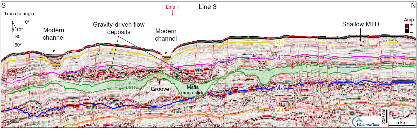
The Tanzania Petroleum Development Corporation and Shell have conducted seismic reflection surveys and drilled some test wells to the SE of Zanzibar Island, an area of major deposition from the eastward flowing Ruaha–Rufiji and Rovuma Rivers. Vittorio Maselli of Dalhousie University in Halifax Nova Scotia and colleagues from the UK, Italy and the Netherlands analysed a wealth of data from these surveys, to discover one of the biggest landslides on Earth (Maselli, V. and 10 others 2020. Large-scale mass wasting in the western Indian Ocean constrains onset of East African rifting. Nature Communications, v. 11, article 3456; DOI: 10.1038/s41467-020-17267-5). The Mafia mega-slide is represented in seismic profiles by a sedimentary unit, up to 300 m thick. It has a highly irregular base that cuts across strata in late-Oligocene to early-Miocene (25-23 Ma) sediments. It covers an area of more than 11,600 km2 and has a volume of at least 2500 km3. The unit’s upper surface is also irregular, suggesting that the unit’s thickness varies considerably. Younger sediments are draped across the irregular top of the slide body. In other, parallel sections the deposit is absent. Unlike the clearly bedded nature of sediments above and below it, the seismic response of the slide deposit is featureless, except for zones of chaotic stratification that reveal slump-folds. Nor is this the only sign of major submarine slides: there are others of lesser extent that predate the base of the Pliocene (5.3 Ma).
A mass movement of this magnitude would have generated a tsunami larger than that which possibly wiped out Mesolithic habitation on the east coast of Britain 8200 years ago due to the even larger Storegga Slide at the edge of the Norwegian continental shelf. The Mafia slide event would have flooded wide tracts of the East African coast. Its estimated age, between 22.9 to 19.8 Ma, is roughly coeval with the initiation of volcanism in the Tanzanian segment of the East African Rift and the onset of rifting and uplift of its flanks. It was probably launched by a major earthquake (>7 on the Richter scale). Such is the pace of current deposition and the thickness of sedimentary build-up since the Pliocene, there is a danger of future slides, albeit of lesser magnitude: the system continues to be seismically active, with recently recorded quakes offshore of Tanzania.

